We’ve had a decent run of good UK weather in recent weeks but that’s all about to change as Storm Hector heads for the north.

Officially named by the Irish meteorological service, Met Eireann, Storm Hector is the seventh storm to be given a moniker in the 2017/2018 storm season. Meteorologists are warning winds reaching gusts of 70mph are expected to cross western Ireland, into Scotland and parts of the north of the UK during Thursday.
As a result, the Met Office in the UK has issued a yellow weather warning, claiming that between 3am and 3pm on 14 June, Storm Hector will “bring a spell of very windy weather with gusts of 50 to 60 mph likely.”
A yellow warning suggests there is a small chance of longer journey times or cancellations to road, rail, air and ferry services, some damage to buildings is likely and there could be powercuts and impacts on mobile phone coverage. The Met Office is even warning people to bring outdoor furniture inside and to secure trampolines. Scroll down to learn more about weather warnings and what they mean.
Storm Hector follows on from Storm Georgina and Storm Fionn which battered the UK in January. In September, Aileen, the first named UK storm of the 2017/2018 season, caused its own problems in the UK with rail routes and more than a thousand homes without power across Nottinghamshire and Lincolnshire. Storm Brian then tore across Ireland in October.
With the storm season well and truly underway, we look at the hurricane and storm names for 2017/2018 to see how they’re decided, we determine the difference between cyclones, storms and hurricanes and explain what those Met Office Weather Warnings actually mean.
Met Office weather warnings
Met Office weather warnings are typically given a rating as well as a colour. The ratings are pretty vague and refer more to the likelihood of a weather event occurring as below:
| High |
|
| Medium |
|
| Low |
|
| Very Low |
|
The colours are a better indication as to how serious and destructive the weather is likely to be ranging from the lowest, yellow, up to the worst, red. Despite being the lowest colour, yellow is typically still strong enough to cause a level of disruption beyond the norm.
Yellow
Yellow Met Office weather warnings means “severe” weather is possible over the next few days and it could affect you. The Met Office encourages people to plan ahead and expect travel delays. Yellow effectively means keep an eye on the latest forecast and be aware that the weather may change.
Amber
When the Met Office issues an Amber weather warning it means there is an increased likelihood of bad weather affecting you, which could disrupt your plans and cause delays, road and rail closures, and even affect power systems.
Red
When a red weather warning is issued it means “extreme” weather is expected. You will need to take immediate action and the weather system is likely to cause widespread damage, travel and power disruption and could even create a risk to life.
How do hurricanes and storms get their names?

According to the World Meteorological Organisation (WMO), storms and hurricanes are given human names because they’re memorable and easily communicable – this avoids confusion when two or more storms are happening at the same time, and makes it easier for broadcasters to relay information to the public.
During the opening decades of the 20th century, names for storms were pretty arbitrary. In the wake of World War II, the US started to use a more formalised system for storms that occurred in the Caribbean Sea, the Gulf of Mexico and the North Atlantic. These are now upheld and altered by the WMO.
The system is based on names in alphabetical order, handed out to storms as they occur. In terms of hurricanes, the list is rotated on a six-year basis, so the name for a storm in 2017 is likely to recur in 2023. The only time a name is replaced is if the particular hurricane has been so deadly that the name becomes strongly associated with a tragic event. For example, Katrina is no longer on the list.
When the system started in 1953, only female names were used. In 1979, male names were added for storms in the Atlantic, Eastern North Pacific and Central North Pacific. The current list alternates between male and female, flipping the order every year (‘male first, female second’ replaced with ‘female first, male second’ and so on).
The UK Met Office and Ireland’s Met Eireann have put together a similar system for storms deemed to cause “medium” or “high” wind impact on UK and Irish shores.
Like the US system, male and female names are alternated and, like the WMO list for the Atlantic, Q, U, X, Y and Z are ignored as these are less common for names in that area. Following a 2015 callout for the public to suggest names, the list includes a number of British-sounding monikers – including Steve, Nigel and Gertrude.
As this internal document shows, the Met Office judges whether an incoming storm has the potential to an a medium to severe impact. If it does, then it gets a name. “This means that all AMBER (ORANGE in the Irish system) and RED warning wind events will be named, along with some YELLOW warning events (i.e. those with a low or very low likelihood of ‘medium’ impacts),” the document reads.
The guidelines emphasise that the choice to name a storm is based on the “potential for a distuptive event”, and while the scheme is focused on large-scale cyclonic windstorms, the systems aren’t precisely defined: “The assumption is that ‘we’ll know one when we see one'”.
Storm names 2017 in the UK

September marked the start of 2017/2018’s season of storms, and a new list of names has been issued by the Met Office and Met Eireann. They picked 21 names from 10,000 submissions and decided on the following:
- Aileen
- Brian
- Caroline
- Dylan
- Eleanor
- Fionn
- Georgina
- Hector
- Iona
- James
- Karen
- Larry
- Maeve
- Niall
- Octavia
- Paul
- Rebecca
- Simon
- Tali
- Victor
- Winifred
Hurricane names 2017 in the US
Below are the names of tropical storms and hurricanes across the Caribbean Sea, Gulf of Mexico and the North Atlantic for the next six years.
| 2017 | 2018 | 2019 | 2020 | 2021 | 2022 |
| Arlene Bret Cindy Don Emily Franklin Gert Harvey Irma Jose Katia Lee Maria Nate Ophelia Philippe Rina Sean Tammy Vince Whitney |
Alberto Beryl Chris Debby Ernesto Florence Gordon Helene Isaac Joyce Kirk Leslie Michael Nadine Oscar Patty Rafael Sara Tony Valerie William |
Andrea Barry Chantal Dorian Erin Fernand Gabrielle Humberto Imelda Jerry Karen Lorenzo Melissa Nestor Olga Pablo Rebekah Sebastien Tanya Van Wendy |
Arthur Bertha Cristobal Dolly Edouard Fay Gonzalo Hanna Isaias Josephine Kyle Laura Marco Nana Omar Paulette Rene Sally Teddy Vicky Wilfred |
Ana Bill Claudette Danny Elsa Fred Grace Henri Ida Julian Kate Larry Mindy Nicholas Odette Peter Rose Sam Teresa Victor Wanda |
Alex Bonnie Colin Danielle Earl Fiona Gaston Hermine Ian Julia Karl Lisa Martin Nicole Owen Paula Richard Shary Tobias Virginie Walter |
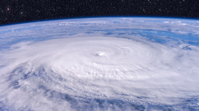
What are the different categories of hurricanes?
Hurricanes are classed according to the Saffir-Simpson hurricane wind scale (SSHWS). This scale put a numerical figure on tropical cyclones that have become more powerful than depressions or storms.
The figure is given based on the intensity of the tropical cyclone’s sustained winds. To make it into the hurricane category, the winds must be at least 74mph (119km/h). From this point, the five categories are as follows:
- Category one: Winds between 74mph and 95mph (119-153km/h)
- Category two: Winds between 96mph and 110mph (154-177km/h)
- Category three: Winds between 111mph and 129mph (178-208km/h)
- Category four: Winds between 130mph and 156mph (209-251km/h)
- Category five: Winds equal or greater than 157 mph (252 km/h)
While there is some criticism that the SSHWS scale doesn’t take factors such as precipitation or storm surge into consideration, it remains a clearly accessible scale that indicates how much damage can be expected if the hurricane meets land.
While all hurricane categories are dangerous, and could cause damage to human structures, things start to become devastating when category three is reached. From category four, a “complete structure failure of residences” can be expected. When it reaches category five, only buildings that are built to withstand extreme environmental conditions will be left standing.
It is very rare for category five hurricanes to make landfall and sustain their intensity. Between 1924 and 2016, only 14 have reached land at category five level, and only once have two category five hurricanes landed in the same year (Dean and Felix in 2007, in Quintana Roo and Nicaragua respectively). Hurricane Katrina was a category five hurricane.
Do hurricanes happen in the UK?
Tropical cyclones generally require sea temperatures higher than those that surround the UK, making our island safe from hurricanes. That said, the Met Office notes that remnants of tropical cyclones can lead to deep depressions on our shores: “Intense mid-latitude depressions, even those which do not originate from a tropical cyclone can produce winds of a strength equivalent to a tropical cyclone.”
One such case happened on 16 October 1987, known as “The Great Storm”, with winds measured reaching 100mph (161km/h). An even stronger depression happened two years later in 1989, with winds reaching 142mph (229km/h), but because this happened on the north of Scotland it didn’t have as large an impact on densely populated areas.
Related Posts
 What are the Symbols Next to Names in Roblox?
 How to Set an Out of Office Automatic Reply in Outlook
 How to Find Your Microsoft Office Product Key
 How To Set an Out-of-office in Google Calendar
 What Is a VPN? How It Works and Common Uses
 Here’s How to Buy the Best VPN for Your Online Safety
 How To Send a Message on Facebook Messenger to All of Your Friends
 How to Send a Message on Facebook to Multiple Friends
 How to Stream Netflix on Discord
Disclaimer: Some pages on this site may include an affiliate link. This does not effect our editorial in any way.


