Google Maps allows you to measure the distance between two points. You can also add multiple points to a map. All of which means you can measure the real-world distance between any selected locations. But when will this come in handy?
This article will explain how to measure distances using Google Maps and the various ways to use the feature on different devices.
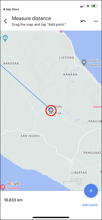
Measure Distance on iPhone & iPad
If you want to measure the distance between two points, you’ll no doubt need to be super accurate. Enter Google Maps. The following steps will enable you to measure the correct distance with an Apple device:
- Open Google Maps.

- Touch and hold the map until a red pin appears.

- Click on “Measure Distance.”
- Move the map until the black circle is where you want to add the next point.
- On the bottom of the map, click on “Add Point.”
- Click the back arrow on the top when you’re finished.


Measure Distance on Android
The process is similar on an Android device. Here’s what you need to do:
- Open Google Maps.
- Touch and hold the screen until a red pin appears.
- Click on “Measure Distance.”
- Move the map until the black circle is where you want to add the next point.
- On the bottom of the map, click “Add Point.”
- Click the back arrow on the top when you’re finished.


Note: On iPhone and Android, when you touch the map on Step 2, don’t touch a name or icon that’s already there. You can undo the last point you made by clicking on “Undo” or clear every point by clicking on “More” and “Clear” on the top.
Measure Distance on a Mac
The following steps will help you measure the distance using a Mac:
- Right click the starting point (control click or two finger click on a trackpad).
- Go to the shortcut menu.
- Click on “Measure Distance.”


Measure Distance on a PC
The following steps will allow you to measure the distance using a PC.
- Open Google Maps.
- Right click where you want your starting point to be.
- Click on “Measure Distance.”
- Click on the map anywhere to make a path to measure.
- Click “Close” on the bottom when you are done.


Note: If you need to move a point, just click and drag it. If you need to remove it completely, all you have to do is click it.
However, you can’t measure the distance if you’re using lite mode. Look for the lightning bolt to determine whether you’re in lite mode.
Other Version of Google Maps
If the map you’re on doesn’t move smoothly, there are two other Google Maps that you can use:
- Default: In this version you’ll just view the map in default mode.
- Satellite: This version will show you more details that includes 2D and 3D views.


If you want to enable Satellite mode, hit the “Layers/Satellite” icon on the bottom left.
How to Enable 3D Mode
In 3D mode, you’ll see buildings and features in 3D, satellite images, and more. This version will give you smoother zooming and transitions. To use 3D mode, follow these steps:
- In Satellite mode, open Google Maps.
- Check to see that the globe view is enabled.
To do this, hover over “Layers,” tap “More,” and click the “Globe View” box. - Tap the 3D icon on the bottom below the compass.


How to Enable 2D Mode
This mode works better on older computers. You won’t have 3D images.
To use 2Dmode go to Google Maps.
How to Calibrate Google Maps
You may be able to get more accurate directions on your mobile devices if you calibrate Google maps.
- Go to “Settings” and then “Location.”
- Move “Wi-Fi Scanning and Bluetooth Scanning” to “On.”


How to Improve Location Accuracy
Google Maps can calculate a distance with excellent accuracy. Unfortunately, it may be a little off from time to time. But there are some things you can do to help improve accuracy.
Turn on Wi-Fi:
Smartphones use Wi-Fi by checking databases of known as Wi-Fi networks. This along with GPS factors into determining your location is correctly.
You can recalibrate your phone by resetting your location services when you turn them off and back on.
- From the top of the screen swipe down.
- Touch and hold the location icon.


Restarting your phone can fix many problems, including inaccurate location data.
- Hold down the power button.
- Select “Restart” or “Power Off.”

Update your Operating System:
This is for iPhone and Android devices. New versions of smartphones also bring new features and fix bugs, so installing the latest updates may also improve your location accuracy.
- Go to “Settings.”
- Click on “System app updater” and check for updates.


Device Links
wp-block-heading">FAQs
What if Google Maps isn’t working on my computer?
You can search for directions to places and businesses just by using Google Search.
What if I’m not seeing the full 3D map version?
You should check your browser, as some will block WebGL used to make the 3D images.
Can I use Google Maps offline?
You’re able to save Google Maps to use offline. The maps you download can be viewed in the Google Maps app.
Map Your Destination
Navigation is a big part of your travel plans and can provide the best route possible. With Google Maps you can follow a route from point A to point B or you make your own route by adding points along the way. Not only will you get the information for how long it will take you to complete your trip, but also the measured distance between the two points.
Have you used Google Maps to measure a distance? Did you use any of the tips and tricks featured in this article? Tell us in the comments section below.
Disclaimer: Some pages on this site may include an affiliate link. This does not effect our editorial in any way.